| |
Canku Ota
|
|
|
(Many Paths)
|
||
|
An Online Newsletter
Celebrating Native America
|
||
|
NOVEMber 2013 - Volume
11 Number 11
|
||
|
|
||
|
Students Learn About
Geography, Landmasses Through Maps
|
||
|
by Craig Boss - Southern
Ute Indian Montessori Academy
|
||
|
credits: photos by Robert
L. Ortiz - The Southern Ute Drum
|
 This
year, our class is engaged in a study of Earth’s geography. This
year, our class is engaged in a study of Earth’s geography.
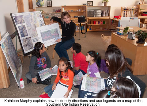
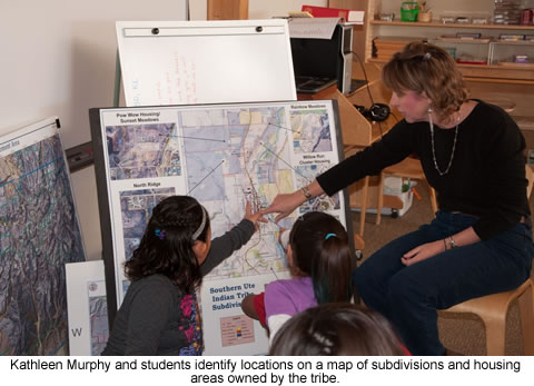
To facilitate our work, I met with Shelly Riddle of the tribe’s Geographic Information System. Together we created a Montessori-style map using colors known to the children for continents. It also includes significant cities as reference points and political boundaries. The 3-by-5-foot map is used in our classroom to identify and locate various geographical features of land and water. Such features are noted on the map with a tag and a number. Hanging next to the map is a corresponding picture of the exact location and number. For the picture, the identifying number is on the back so children can quiz themselves. To date, we have 13 different land and water forms identified and 100 specific places with photographs. We anticipate no end to this project. We are likely to pass the 200-places mark before spring and could easily pass 50 different land and water forms this school year.
Their first introduction to maps is simple. It begins with basic globes. The first theme is a separation of land and water. After that comes an introduction to continents. Early this school year, we began to explore various land and water forms. As we learned about lakes, rivers, islands, deserts, mountains and such, our children developed a desire to see how such things looked in reality. As pictures are presented, a curiosity is ignited about were such places are. A few features immediately planned are sand dunes, fjords, archipelagos, cliffs and beaches. The students have studied islands, bays, peninsulas, straits, lakes, valleys, glaciers, isthmuses, volcanoes, mountains, deserts, waterfalls, canyons, caves and rivers.
They also learn about nearby places, such as Lake Navajo and Red Mountain. Children have experienced the vastness of Earth as well as its interconnectivity and people, and learned to appreciate its beauty and the magnificence while becoming aware of how life might be in a variety of places. The students have learned the usefulness of maps and their specific themes. Students read and create maps and use them to organize their information, including newly discovered landforms or bodies of water. Our project has expanded the children’s understanding of the globe. They are aware of the wonders created for us to enjoy, and they seek new ones from pole to pole. As we continue to explore the globe, we will emphasize the interconnectivity of all things and the important responsibility we all have to Earth and each other as citizens of our shared planet. |
 On
Friday, Dec. 7 Riddle and Kathleen Murphy met with Lower Elementary
students in the Kuch One classroom to discuss her work and potential
careers in her field.
On
Friday, Dec. 7 Riddle and Kathleen Murphy met with Lower Elementary
students in the Kuch One classroom to discuss her work and potential
careers in her field.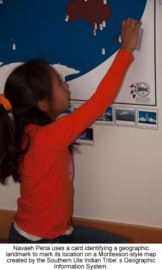 Students
are presented with a broad landform, such as a cave, and given a
working definition with photographs. The photographs display variety
and are taken from all areas of the Earth. Children also learn how
Internet maps and atlases are used to locate significant landforms
and see places and things otherwise unavailable to them.
Students
are presented with a broad landform, such as a cave, and given a
working definition with photographs. The photographs display variety
and are taken from all areas of the Earth. Children also learn how
Internet maps and atlases are used to locate significant landforms
and see places and things otherwise unavailable to them.|
|
||
|
|
||
|
|
||
|
|
||
| Canku Ota is a free Newsletter celebrating Native America, its traditions and accomplishments . We do not provide subscriber or visitor names to anyone. Some articles presented in Canku Ota may contain copyright material. We have received appropriate permissions for republishing any articles. Material appearing here is distributed without profit or monetary gain to those who have expressed an interest. This is in accordance with Title 17 U.S.C. Section 107. | ||
|
Canku Ota is a copyright ©
2000 - 2013 of Vicki Williams Barry and Paul Barry.
|
||
| |
|
|
|
The "Canku
Ota - A Newsletter Celebrating Native America" web site and
its design is the
|
||
|
Copyright ©
1999 - 2013 of Paul C. Barry.
|
||
|
All Rights Reserved.
|
||