| |
Canku Ota
|
|
|
(Many Paths)
|
||
|
An Online Newsletter
Celebrating Native America
|
||
|
October 2018 - Volume
16 Number 10
|
||
|
|
||
|
Prospects Are Looking
Up For This Gulf Coast Tribe Relocating To Higher Ground
|
||
|
by Doug Herman - Smithsonian.com
|
||
|
As
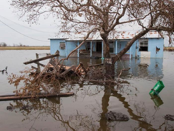
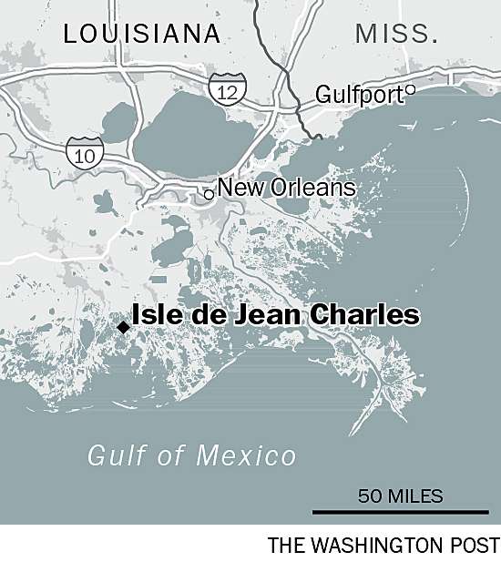
Louisiana's Isle de Jean Charles slips away, the Biloxi-Chitimacha-Choctaw
tribe plans community renewal and a museum for their new home
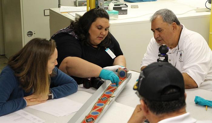
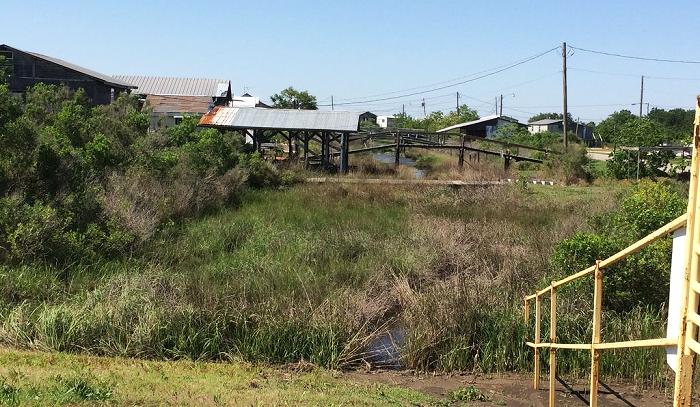
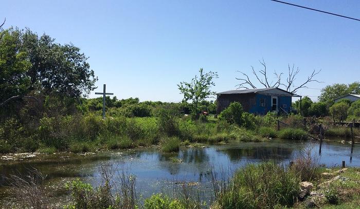
"We are displaced. Our once large oak trees are now ghosts. The island that provided refuge and prosperity is now just a frail skeleton," says Chantel Comardelle, tribal secretary of the Biloxi-Chitimacha-Choctaw, as we sit in one of the few houses left on the Louisiana Gulf Coast island, which has shrunk from 34.5 square miles to half a square mile. Out front a stagnant canal festers, obstructed by a recent levee built by the Army Corps of Engineers to protect the remainder of the island. The community of Isle de Jean Charles understands and widely accepts that climate change is affecting them. "The weather patterns are changing; storms are much more frequent" Comardelle says. "People really started leaving in the 1960s. In the 1980s and 1990s, following storms like Juan and Hurricane Andrew, a lot of people left. Their houses got blown away—torn up, or flooded—completely gone, some of them. Many didn't want to put money in and then a couple years later have to do the same." Her father, deputy chief Wenceslaus Billiot Jr adds: "Every hurricane, someone leaves because their house gets blown away." Right now, 95 percent of the tribal community no longer lives on the Isle. The residents and tribal members are now the first federally-funded community to be moved because of environmental degradation and displacement. In 2016, the Department of Housing and Urban Development (HUD) awarded a $48.3 million grant through Louisiana's Office of Community Development-Disaster Recovery Unit (OCD-DRU) to fund the relocation of the Isle de Jean Charles band of the Biloxi-Chitimacha-Choctaw tribe. Following a two year search and negotiation some 500 acres of former sugarcane land was purchased for nearly $12 million near Schriever in southern Louisiana. Development is slated for 2019. In anticipation of the move and amidst plans for relocation late last year, a tribal delegation arrived at the Smithsonian Institution to view the cultural heritage collections related to their tribe and to their history and that have been held for decades at the National Museum of Natural History and the National Museum of the American Indian. As part of the Recovering Voices initiative to recover cultural knowledge, the delegation examined museum artifacts and was asked to contribute memories and recollections.
"We had four generations there," Comardelle says, "my kids traveled up with us, seeing this dugout canoe from our ancestors. With all the storms and such, we've lost a lot of things, including pictures. So, to see something of that magnitude that was preserved there, that was just amazing." "I would never have imagined they had so much stuff," Billiot says. "They had some artifacts that they didn't know what they were. We showed them what they were and how they worked. They had a little device for hooking up the Spanish moss and spinning it into rope, and they didn't know what that was for. There was a pirogue from the early 1800s—dugout—that was from here." "We often talk about displacement of our tribe here, but as a whole tribe, we are displaced from our parent tribes," says Comardelle. "And that was evident seeing the artifacts. They had baskets like ones from the Choctaw tribe of Alabama. Same weave pattern. And the games, we had similar games, we just didn't have the same materials. For a tribe like us having to go back and find things and put pieces together, being able to sit in the collections and see baskets from the Choctaws that you know the pattern and know how they're made; and clothing of the Biloxis that are similar to ours; it proves that we do have this history, and it helps to put those pieces back together and confirm that history." Picking Up the Pieces Putting the pieces back together again was important to state officials, too. According to Jessica Simms of the OCD-DRU, the state of Louisiana wanted to make sure that all Isle residents would be settled in a location that was suitable to their socioeconomic and cultural values and that former Island residents could rejoin the community in its new location. "Many of whom," she says, "were displaced over time following repetitive disaster events." According to elderly residents on the island, Isle de Jean Charles was once home to as many as 750 people, occupying 70 homes arranged on both sides of the bayou in a line village pattern. Now only 20 or so families remain. Louisiana is said to be home to more American Indian tribes than any other southern state. There are four federally recognized tribes, ten tribes recognized by the state of Louisiana, and four tribes without official status. Located in Terrebonne Parish, the Isle de Jean Charles tribe is one of three ancestrally related but independent tribes of what was, until recently, the Biloxi-Chitimacha Confederation of Muskogees. This is traditionally Chitimacha country, and scholars estimate that in 1650, there were 4,000 Chitimacha Indians. Up through the 20th century, 13 to 15 names of their many villages could be recalled and their sites identified.
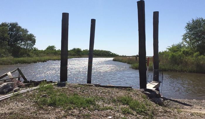
But there was a lot of movement of Louisiana tribes when the French and Indian war ended in 1764. And even more with the Indian Removal Act. The Biloxis had already been well traveled and knew the channels and ridges of the area. Some Biloxi and Choctaw Indians, fleeing the Trail of Tears, sought refuge first in the Houma area north of the Isle, then further down in the remote marshes of the Mississippi delta. There they commingled with the Chitimacha, hoping American authorities would not find them and force them onto reservations in Oklahoma. The language is mostly a mix of Choctaw with French, and Comardelle's father and grandmother speak to each other in these soft Cajun tones. An Island for Trade, Art and Oil The Isle was once accessible only by small dugout canoes, or pirogues. Later the canal was made bigger so boats could navigate the area. "When the great depression happened, people on the Isle didn't even know it was happening," recalls Billiot. "People on the Isle lived by trade—fishing, making furniture, building houses, on up into the 1940s. The community took care of itself. We had three stores on the island when I was growing up. The land provided blackberries. Once a year we would have a big party where we killed a pig for the community. We raised our own chickens, cows." Palmetto baskets—made from the heart of the young palmetto before it starts flaring up—became an art form. Then the oil fields came in and started making canals to bring in more rigs. In 1953 a road was built to access the oil tanks. Salt water seeped into the canals. "When I was growing up, it was mostly brackish water, lots of fresh water," Comardelle recalls. "I was told these were rice fields, but you wouldn't know because now it's just water over there." The road accessing the Isle from the mainland used to have land on either side. Now it's all water, and that water all too often flows over the road itself. The Fragility of an Ecosystem "The top few meters of land consists of mostly organic matter, made up of plants and roots—a biological system," explains R. Eugene Turner of the department of oceanography and coastal sciences at Louisiana State University. "When it dries out, the soil oxidizes and turns to CO2. And the land sinks." The ecosystem depended on the growth of plants and the production of organic matter to produce the soil. The tides are only 6 to 12 inches during the day, a bit higher in summer, but this provided enough water to keep the plants surviving. The problem, according to Turner, stems from the dredging of canals through this land by the oil industry, which began early in the 20th century and accelerated after 1940. The canals are dredged much deeper than a natural channel—12 to 15 feet versus a foot or two—and then the materials dredged are piled on either side to build a levee called a spoil bank, which can be up to ten feet high. It doesn't let water in that often, and when it does, it doesn't get out as easily.
"The total length of these spoil banks is enough to cross south Louisiana 80 times—or to go to London and back with miles left over," Turner says. "These 'spoil banks' really interfere with the natural flow of water. They are higher than the water would ever go, except in a hurricane." The land behind them does not get the water it needs, so the plants die, and as the organic soil dissolves into CO2, the land sinks. "Where there are more canals, there's more land loss; where there are less canals, there's less land loss, so these are correlated," Turner points out. When the plants can't grow, they can't add to the land, and what's down there turns to CO2. "It depends on always growing on top," Turner says. "Add sea level rise to this subsidence and it's going to turn to open water. Sea level rise is going to start a whole new chapter of land loss." What It Took to Get to 100 Percent Buy-In "Back then, a hurricane hit, we'd get a foot of water on the land here," Billiot states. "Now, if there's a hurricane in Texas, we get seven or eight feet of water here. There's no more land, no buffers, no barrier islands to stop the surge. Not just from the canal digging, but hurricanes, and subsidence. And sea level rise. There are some docks that in the 1970s were two feet above the water. Now they're under water and they had to build a new dock above it." Oil companies were the bread and butter of the economy. "You couldn't fight them," say Billiot, "because everything is oil over here, it would be a losing battle. On the other side, most of the people down here work in the oil field, so it's a double-edged sword." The Tribal Community began discussions about relocating Isle residents in 1999. That year, the Corps of Engineers changed the path of the levee so that it no longer protected the remaining homes. In 2002, community members began working with the Corps to relocate the Isle's residents, but the Corps would not move them individually, only as a community; only if there was 100 percent buy-in. "How often do you get 100 percent?" Billiot muses. Leaders managed to get about 90 percent of the residents to agree, but it was not enough.
In 2008, after Hurricanes Gustav and Ike, the Tribal Community tried again to seek funding and relocate tribal members from the Isle, and found a place that seemed like it would do the job. They had support from the local government and some other funders and backers, but the people from the area they were looking to move to protested, saying their presence there would cause more flooding. "We were Indian and they were white," Comardelle says. "The chief got up, gave his introduction, and was told 'Your time's up, please sit down.'" But this effort, like the first one, required 100 percent buy-in, and not everyone was on board. Planning for a Better Future "We kept looking for ways to help our tribe, which led to continued planning," says Comardelle. "The Tribal leaders aligned us with some non-profits, who said they could help. At the time, the planning was not specific, just planning for a better future. The planning was for a place where the tribal community to live and not deal with environmental issues every other moment. The Isle of Jean Charles community planned with visions and dreams of a future getting back to the way life on the Isle used to be, when our community was fruitful and not just a ghost if itself." The planning process eventually lead to a meeting with the Louisiana Department of Community Development. Several Tribal communities were present to discuss applying for the initial phase of a National Disaster Resilience Competition grant. In 2016, HUD made $48.7 million available to relocate the Isle's residents. "They were one of 67 entities in the USA that could apply and win," says Pat Forbes, executive director of the Louisiana Office of Community Development. "We are HUD's grantees for this project, so we administer the grant in compliance with them. The task is to move a community from an at-risk place to a lower-risk place where they can be high and dry for a long time. And to do that in such a way that can demonstrate lessons learned and best practices as we go through it, so we will be better at it the next time we try."
"We were familiar with the tribe's previous effort to move," Forbes adds, "so we engaged with them and they participated with us as we wrote the application. Now our role is to ensure that we bring the project to fruition, meaning getting everyone in this community who wants to go, moved from the Isle. They could be moving to this new location, or somewhere else. We want to lay the groundwork for a model of how to do this in the future." The model for future communities is being developed while navigating a complicated process. "After HUD awarded the grant, the State's first step was to conduct a census of the Isle's residents," says Simms of the OCD-DRU, "and document existing infrastructure on the Isle. Through this initial effort, the State began forming vital relationships with the Isle's residents and its broader community. The residents determined they wanted to be further up away from the coast. But it was difficult to balance the desire to live a safe distance from the water with the need for proximity so that they could continue their traditional trades. Several possible locales were considered, but residents wanted to live on higher ground. Then they sought potentially available tracks of land that would be suitable, given everything they wanted to do. "Island residents submitted preference surveys," Simms explains, "indicating which site they preferred. The site we are under option on was the one that residents ultimately indicated they wanted to move to."
Higher Ground The State purchased a binding option on land that had been used for sugarcane fields north of Houma, but can't commit HUD funds until after an environmental review. The new land is 12 feet above sea level. "It's north of Highway 90," Comardelle says, "where they say everyone should be, based on a 100-year map projection of coastal flooding and sea level rise. It has good drainage, and it's safe for future development." The new community would initially involve resettlement of current Island residents. But the intention, and the expectation, is that tribal descendants of Isle de Jean Charles could also return to the new site. "It needs to grow back into a robust community," Forbes says. "While we might move 45 to 50 families from the Island, we need to build an infrastructure that can take 150 to 200 homes. They'll use HUD standards, so there aren't necessarily extended families living in one house like they are now. Lots of folks on the Island are currently living in substandard housing." "Lots of resettlements actually displace tribes," Comardelle explains. "We're being displaced by the environmental changes and things happening inside our community. When we get to the resettlement, it will actually bring the tribe back together. People who left can come back to the community. You'll be able to walk next door and it will be your aunts and your cousins, like it used to be. And then we can get our culture back. Kids can learn how to weave baskets, make cast nets, build boats. And we'll have our community back to where it is self-sustaining again: if someone was sick, the neighbors of other members of the community would cook and feed them. But now they might be 45 minutes away. We'll be all close to each other again."
Weaving Together
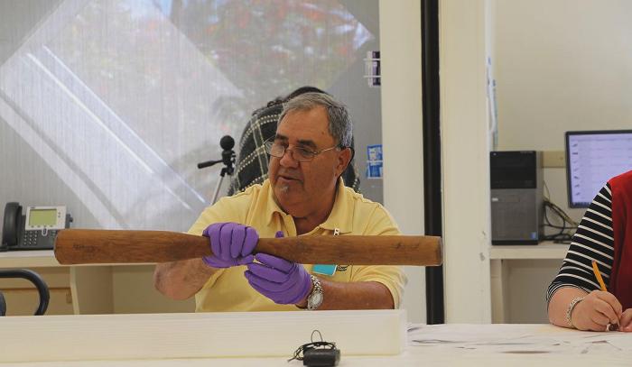
a Community Comardelle is now planning a tribal museum and has acquired a museum studies degree to learn about collecting. "We want a part where we show our history, but we also want an interactive part where we teach our history. Here's how you weave a basket. Not just for us, but for the outside community. The museum on the resettlement plan is not just a building, but a heart pumping and circulating our past into the present and on to the future." "We can demonstrate how to make a pirogue," Billiot adds. "I have a blueprint for it. I created it in AutoCAD." "We have only a few things for the collections," Comardelle remarks. "Right now, we can't collect because we have no place to put things. So, we're looking at how we can start a digital archive. A lot of people still have old pictures; we want to be able to scan them so not only do we have them, but the people themselves can get prints back from us if the originals are lost. We can have an archive for private use and also to show the outside community—with permission." The connections made are the cultural detail being brought into the second phase of master planning with the State to ensure the new community retains the Tribe's cultural identity. The community collaboration and multi-agency interaction is a component of the master planning process that aids in producing a model for all communities across the coastal region. "We've proven that you can take and adapt to whatever land you're in, and still retain your culture and your identity, Comardelle adds. "I have no doubt that we will be able to do that here." The writing is on the wall not just for this tribe, but for other Louisiana tribes. As early as 1987, scholars sounded a warning: "Today, the decline in Louisiana's Indian population is matched by the deterioration and outright destruction of the state's once magnificent natural environments. Many tribes have disappeared; the rest are decimated. The likelihood of their eventual demise is strengthened by environmental ruin. The problem is one for all Louisianans. Irreparable ecological damage can be tolerated no longer, and the Indian, like his neighbors, have begun to demand protection." Now that demand has manifested into action. "We understand the ramifications of our work, relative to others who are going to be going through this," Forbes points out. "So, there's the importance of getting it right and learning from it, so other people can learn from our experiences and do it better than we have on the first pass. It's so new; it's going to be a constantly improving approach. "Nobody is really dying to leave the place where they grew up, and where they live and own property. Every resettlement project is going to face this," he says. "Louisiana is going faster than anywhere else in the USA, between sea level rise and ground subsidence making for a higher, relative sea level rise. So, we are the vanguard of this experience." |
|||||||||||||||

|
|
|
||
|
|
||
|
|
||
|
|
||
| Canku Ota is a free Newsletter celebrating Native America, its traditions and accomplishments . We do not provide subscriber or visitor names to anyone. Some articles presented in Canku Ota may contain copyright material. We have received appropriate permissions for republishing any articles. Material appearing here is distributed without profit or monetary gain to those who have expressed an interest. This is in accordance with Title 17 U.S.C. Section 107. | ||
|
Canku Ota is a copyright ©
2000 - 2018 of Vicki Williams Barry and Paul Barry.
|
||
| |
|
|
|
The "Canku
Ota - A Newsletter Celebrating Native America" web site and
its design is the
|
||
|
Copyright ©
1999 - 2018 of Paul C. Barry.
|
||
|
All Rights Reserved.
|
||