| |
Canku Ota
|
|
|
(Many Paths)
|
||
|
An Online Newsletter
Celebrating Native America
|
||
|
June 2021 - Volume 19
Number 6
|
||
|
|
||
|
Rare Aztec Map Reveals
A Glimpse Of Life In 1500s Mexico
|
||
|
by Greg Miller - National
Geographic
|
||
|
A colorful map
shows how indigenous and Spanish cultures mixed after their worlds
collided.
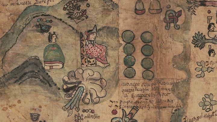
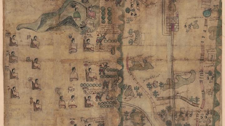
Early maps of the Americas made by indigenous people are rare—extremely rare. This map, dated 1593, is one of fewer than 100 such documents that have survived the ravages of time. It provides a fascinating glimpse into the early interactions between the indigenous people of Mexico and the recently arrived Spanish. The map shows the land holdings and geneology of a family in central Mexico. It covers an area that runs from just north of Mexico City to just below Puebla, roughly 100 miles away to the southeast. The family, identified as “de Leon,” traced their lineage to the red figure seated in the middle of the image above, who was known as Lord-11 Quetzalecatzin. A century before the map was made, he was the major political leader of the region writes John Hessler, curator of the Jay I. Kislak Collection of the Archaeology of the Early Americas at the Library of Congress in a recent blog post about the map. Many other family members appear on the map too. The map shows both indigenous and Spanish influences. “On the one hand, the map is a traditional Aztec cartographic history with its composition and design showing Nahuatl hieroglyphics, and typical illustrations,” Hessler writes, referring to the indigenous language of the region. The bold colors on the map come from natural dyes, including Maya Blue (made from indigo plant leaves and a type of clay) and carmine (made from a cactus-dwelling insect). “On the other hand,” Hessler continues, “it also shows churches, some Spanish place names, and other images suggesting a community adapting to Spanish rule.” The names of several indigenous leaders include the Spanish honorific “don,” and the names of some, such as “don Alonso” and “don Matheo,” indicate that they’d been baptized with Spanish names. The map provides a rare opportunity for scholars to study the earliest interactions between these two very different cultures. It was acquired recently by the Library of Congress, and it’s now freely available on their website, where you can explore it in detail.
|
||||
|
|
|
||
|
|
||
|
|
||
|
|
||
| Canku Ota is a free Newsletter celebrating Native America, its traditions and accomplishments . We do not provide subscriber or visitor names to anyone. Some articles presented in Canku Ota may contain copyright material. We have received appropriate permissions for republishing any articles. Material appearing here is distributed without profit or monetary gain to those who have expressed an interest. This is in accordance with Title 17 U.S.C. Section 107. | ||
|
Canku Ota is a copyright ©
2000 - 2021 of Vicki Williams Barry and Paul Barry.
|
||
| |
|
|
|
The "Canku
Ota - A Newsletter Celebrating Native America" web site and
its design is the
|
||
|
Copyright ©
1999 - 2021 of Paul C. Barry.
|
||
|
All Rights Reserved.
|
||